


SityTrail - ubaye depart du gite

gerardmicheline
User
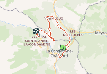

Length
13.4 km

Max alt
1999 m

Uphill gradient
904 m
Km-Effort
24 km

Min alt
1273 m

Downhill gradient
490 m
Boucle
No
Creation date :
2021-03-13 14:08:34.215
Updated on :
2021-03-13 14:15:16.545
5h28
Difficulty : Very difficult

FREE GPS app for hiking
 SityTrail
IGN / Geographical institutes
SityTrail Plus
The world is yours!
About
Trail Walking of 13.4 km to be discovered at Provence-Alpes-Côte d'Azur, Alpes-de-Haute-Provence, La Condamine-Châtelard. This trail is proposed by gerardmicheline.
Description
prevoir une navette
Positioning
Country:
France
Region :
Provence-Alpes-Côte d'Azur
Department/Province :
Alpes-de-Haute-Provence
Municipality :
La Condamine-Châtelard
Location:
Unknown
Start:(Dec)
Start:(UTM)
320668 ; 4925242 (32T) N.
Comments